If you've noticed the near-apocalyptic looking sunrises or sunsets in the last few weeks, it's not your eyes playing tricks on you.
The phenomenon is actually due to smoke spreading from the wildfires out west, according to Wayne Schlingman, director of Ohio State University's Arne Sletteback Planetarium.
Even some 2,000 miles away, the blazes across California, Montana, Idaho, Washington and other western states and even Canada are blanketing the East Coast with smoke and particulates.
“When you start adding a lot of this fine particulate from the smoke that does not settle out overnight, it's carried continually to upper level winds,” Schlingman told the Mount Vernon News. “And so you can get these blood-red morning sunrises, and they can be very dark in the evening as well.”
It's enough of a problem that the U.S. government monitors smoke as part of its air quality ratings via AirNow.gov, which presents the official U.S. smoke forecast.
"It's really bad everywhere," Schlingman told the News.
Schlingman spent two weeks on the West Coast recently and observed a milky white sky and yellowish, filtered look of the daytime sun.
"But that wasn't even in the really heavy smoke areas closer to the fires," he said. "The smoke [can be] thick enough that you can stare straight at the sun without worrying about hurting your eyes because it's almost impossible to find.”
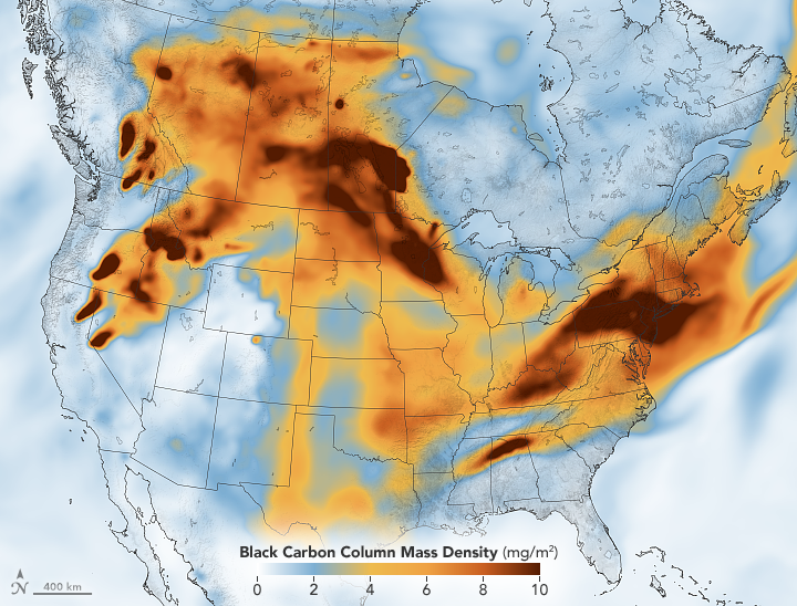
According to a NASA map, smoke from western wildfires has traveled across the U.S., leaving a dark orange band over Kentucky, Ohio, Pennsylvania and points further east.
AirNow.gov reports a “smoke plume” in the area near Mount Vernon. However, it’s unlikely you would be able to actually smell smoke at ground level. In fact, the overall air quality rating was 23 as of this writing, well within the “good” range.
The primary impact is visual, since the fine-particulate smoke blown from a wildfire can stay aloft, trapped in the upper layers of the atmosphere, AirNow.gov explains.
So even with a 2,000-mile buffer between Ohio and California, the presence of wildfires can be felt.
“That's what makes weather forecasting so challenging,” Schlingman said. “If we want to say what is happening in a week, we have to know what is happening everywhere on the earth and model all that out.”